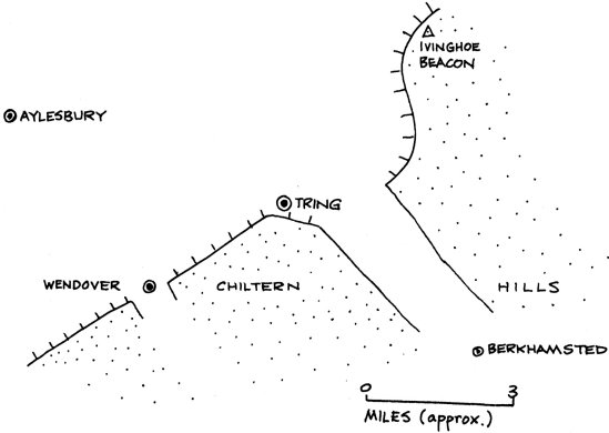
The Site And Situation Of Tring

From our two visits to Tring we obtained information which helped us to suggest reasons for the
towns situation. Its site is immediately west of the northern opening of the Tring Gap which is
the valley cut through the Chiltern Hills by the R. Bulbourne. To the north of the town lies
flat, fairly low country, but just to the south are the Chiltern Hills, composed of chalk,
rising to over 800 feet, forming a scarp slope steep in places. The more gentle dip slope falls
away to the south east. To the south east of Tring is the Wendover Gap, occupied 6y the
Misbourne Brook.
|
|
The advantages of this site include:-
a) It lies in a favourable position to be a modal point in the communications network. Routes
along the foot of the chalk scarp take advantage of lower, more gentle relief e.g. B489 to
Dunstable and A4011 to Wendover. Routes from north to south pass nearby as they use the Tring
and Wendover Gap, e.g. the A41 and A413.
|
The Tring Gap is also used by the railway going north-west from London.
Incidentally, this railway was the scene of the "Great Train Robbery"
at Linslade, about six miles north of Tring. Another communications link using Tring Gap is the
Grand Union Canal from Birmingham to London.
b) The nature of the relief immediately surrounding Tring offers a sheltered site for the
town.
c) The geology of the Tring areas is such that some surfaces are dry e.g. on exposed chalk
whilst others have surface drainage e.g. the Greensand to the north of Tring. The latter
provide opportunities for water supply both in the form of streams and sites for reservoirs.
Due to its relative proximity to London, Tring is a dormitory town for some of London's
workers and large new estates are flourishing around its outskirts.
T. Walsh
| School Trips Index
| 1968 Magazine Index
| HOME |