Journeys To & From School
A section of the number of times late per month due to transport delays was included, but insufficient information was given and that which was given was apparently unreliable, and so ignored.
The forms were printed - about 550 of them - and distributed via the registers. We would like here to thank the two Secretaries for their great patience and co-operation - they must have been sick of the sight of us - and we certainly never wanted to see the inside of the office again.
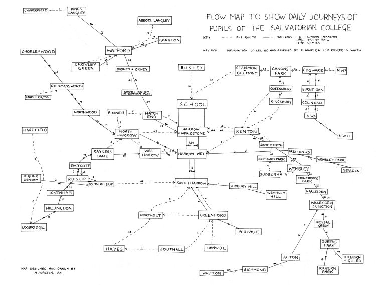
We checked to see how representative a section of the school we had. Form lists were obtained and two of us spent an afternoon carefully checking names. There were some shattering results - 1H and the Upper Sixth were both totally missing (apparently lost in transit) and 40 or 50 other names were outstanding. We had a total of 130 names missing. More forms were printed, the old ones checked and corrected. Eventually (after about three weeks) we accepted a final result, 10 forms down on the official school strength. With the aid of an adding machine borrowed from Dr. Lewis we compiled average times, morning and evening, for each postal area and transferred these to maps as described above. A flow map, which is now on the Geography Room wall, together with an actual route map, was prepared and drawn up to scale, and is now available for viewing (any resemblance which it bears to a steam boiler is totally unintentional - convenience forced the design on us.) A copy of the flow map is included in the magazine (see below), as we feel it is the most interesting of the maps. We do not guarantee total accuracy, but it does represent a reasonably true picture.
R. Amor,
G. Hill,
P. Rodger,
M. Walton.
(Upper Sixth).
 |